 NGDC for Kenya
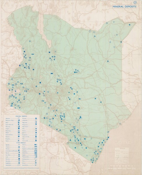
Mineral Deposits 1969
Originally called the Mineral Deposits map (1969) and revised in 2001, this map was re-released as the Mineral Occurrence Map of Kenya in 2011. The base map is the Administrative boundaries map SK81A at 1:1 million scale overlaid with the location recorded location of mineral occurrences.
Simple
- Date (Publication)
- 1969
- Edition
-
1
- Presentation form
- Digital map
- Status
- Completed
- Maintenance and update frequency
- As needed
- Keywords
-
-
Mineral Occurences
-
Minerals
-
Mineral Exploration
-
Mining
-
- Use limitation
-
Internal Only
- Access constraints
- Other restrictions
- Other constraints
-
Internal Only
- Other constraints
- No specifed conditions apply
- Denominator
- 1000000
- Metadata language
- English
- Topic category
-
- Geoscientific information
- Description
-
Kenya
- Supplemental Information
-
{"Translation Needs":"",
"Number of pages (Hardcopy)":"",
"Archive Location (Hardcopy)":"",
"Location in Archive (Hardcopy)":"",
"Risk and Impact":"",
"Vital asset to the organisation?":"",
"Current Asset Volume":"1.49",
"Digitalizing status":"Scanned",
"Scanned Date":"",
"Name of Staff Scanning":"",
"Digital Asset location":" http://gdcs1.gdc.com/SpatialData/Raster/Geological/Mineral_Occurrences/Original_Arc_1960_DD/Mineral_Deposits_1969.JPG",
"Retention period":"",
"Shared with":"",
"Comments":""}
- Reference system identifier
- 4210
- Distribution format
-
-
.jpg
()
-
.jpg
()
- OnLine resource
-
Mineral Deposits 1969
Originally called the Mineral Deposits map (1969) and revised in 2001, this map was re-released as the Mineral Occurrence Map of Kenya in 2011. The base map is the Administrative boundaries map SK81A at 1:1 million scale overlaid with the location recorded location of mineral occurrences.
- Statement
-
Map has been through three iterations, first published in 1969, revised in 2001 and updated again in 2011. Copies of all three versions are held along with copies of the map used during the update process.
- File identifier
- 56f8cb0a-38fc-4a28-b89e-6f47edb3a29a XML
- Metadata language
- English
- Hierarchy level
- Dataset
- Date stamp
- 2019-10-22
- Metadata standard name
-
National Geodata Centre for Kenya Schema
- Metadata standard version
-
1.0
Overviews
Spatial extent
Provided by
