 NGDC for Kenya
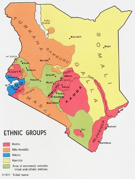
Ethnic Groups Map
Ethnic group map illustrates the extent and distribution of the different ethnic groups within Kenya. Major towns are indicated on the map but no further topographic detail is included.
Simple
- Date (Publication)
- 1974
- Presentation form
- Digital map
- Status
- Completed
- Maintenance and update frequency
- Not planned
- Keywords
-
-
Ethnic Groups
-
- Use limitation
-
Internal Only
- Access constraints
- Other restrictions
- Other constraints
-
Internal Only
- Other constraints
- No specifed conditions apply
- Denominator
- 1000000
- Metadata language
- English
- Topic category
-
- Society
- Description
-
Kenya
- Supplemental Information
-
{"Translation Needs":"",
"Number of pages (Hardcopy)":"",
"Archive Location (Hardcopy)":"",
"Location in Archive (Hardcopy)":"",
"Risk and Impact":"",
"Vital asset to the organisation?":"",
"Current Asset Volume":"0.11",
"Digitalizing status":"Scanned",
"Scanned Date":"",
"Name of Staff Scanning":"",
"Digital Asset location":" http://gdcs1.gdc.com/SpatialData/Raster/Topographic/Socio_Economic/Kenya_Ethnic_Groups_1974.jpg",
"Retention period":"",
"Shared with":"",
"Comments":""}
- Distribution format
-
-
.jpg
()
-
.jpg
()
- OnLine resource
-
Ethnic Groups Map
Ethnic group map illustrates the extent and distribution of the different ethnic groups within Kenya. Major towns are indicated on the map but no further topographic detail is included.
- Statement
-
Maps have been created as report illustrations. No details are available as to the name of the report they were used in or the age of the illustrations.
- File identifier
- 610dab31-9afb-4bda-b995-25378c3bf7a8 XML
- Metadata language
- English
- Hierarchy level
- Dataset
- Date stamp
- 2019-10-22
- Metadata standard name
-
National Geodata Centre for Kenya Schema
- Metadata standard version
-
1.0
Overviews
Spatial extent
Provided by
