 NGDC for Kenya
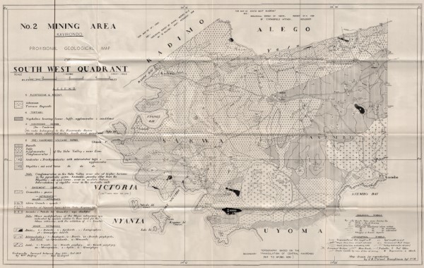
No2 Mining Area Soutwest Quadrant
No2 Mining Area Soutwest Quadrant
Simple
- Date (Publication)
- Edition
-
1
- Presentation form
- Digital map
- Status
- Completed
- Maintenance and update frequency
- Not planned
- Keywords
-
-
Mineral Exploration
-
Mining
-
- Use limitation
-
Internal Only
- Access constraints
- Other restrictions
- Other constraints
-
Internal Only
- Other constraints
- No specifed conditions apply
- Denominator
- 63360
- Metadata language
- English
- Topic category
-
- Geoscientific information
- Description
-
Kenya
- Supplemental Information
-
{"Translation Needs":"",
"Number of pages (Hardcopy)":"",
"Archive Location (Hardcopy)":"",
"Location in Archive (Hardcopy)":"",
"Risk and Impact":"",
"Vital asset to the organisation?":"",
"Current Asset Volume":"5.35",
"Digitalizing status":"Scanned",
"Scanned Date":"",
"Name of Staff Scanning":"",
"Digital Asset location":" http://gdcs1.gdc.com/SpatialData/Raster/Geological/Mineral_Exploration/No2_ Mining_Area_Soutwest_Quadrant.jpg",
"Retention period":"",
"Shared with":"",
"Comments":""}
- Distribution format
-
-
.jpg
()
-
.jpg
()
- OnLine resource
-
No2 Mining Area Soutwest Quadrant
No2 Mining Area Soutwest Quadrant
- Statement
-
Collection of maps showing various mining licences, sites and exploration blocks. Maps cover coal, petroleum and other types of mineral exploration. Maps appear to be version 1, no later or previous versions have been identified. Scanned copy of published paper map
- File identifier
- 64861923-4245-4c27-ba46-b570c7fa5613 XML
- Metadata language
- English
- Hierarchy level
- Dataset
- Date stamp
- 2019-10-22
- Metadata standard name
-
National Geodata Centre for Kenya Schema
- Metadata standard version
-
1.0
Overviews
Spatial extent
Provided by
