 NGDC for Kenya
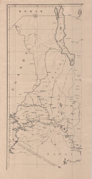
International Boundary
International Boundary
Simple
- Date (Publication)
- Presentation form
- Digital map
- Status
- Completed
- Maintenance and update frequency
- Not planned
- Keywords
-
-
Boundries
-
- Use limitation
-
Internal Only
- Access constraints
- Other restrictions
- Other constraints
-
Internal Only
- Other constraints
- No specifed conditions apply
- Metadata language
- English
- Topic category
-
- Boundaries
- Description
-
Kenya
- Supplemental Information
-
{"Translation Needs":"",
"Number of pages (Hardcopy)":"",
"Archive Location (Hardcopy)":"",
"Location in Archive (Hardcopy)":"",
"Risk and Impact":"",
"Vital asset to the organisation?":"",
"Current Asset Volume":"17.83",
"Digitalizing status":"Scanned & Georeferenced",
"Scanned Date":"",
"Name of Staff Scanning":"",
"Digital Asset location":" http://gdcs1.gdc.com/SpatialData/Raster/Topographic/National/Original_Arc1960_DD/Kenya_International_Boundary.jpg",
"Retention period":"",
"Shared with":"",
"Comments":""}
- Distribution format
-
-
.jpg
()
-
.jpg
()
- OnLine resource
- International Boundary
- Statement
-
Scanned copy of published paper map
- File identifier
- beea7940-aded-48ac-a891-2df6522e3105 XML
- Metadata language
- English
- Hierarchy level
- Dataset
- Date stamp
- 2019-10-22
- Metadata standard name
-
National Geodata Centre for Kenya Schema
- Metadata standard version
-
1.0
Overviews
Spatial extent
Provided by
