 NGDC for Kenya
250000
Type of resources
Topics
Keywords
Contact for the resource
Provided by
Formats
Update frequencies
status
Scale
-
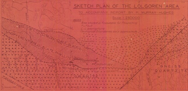
Lolgorien Area
-
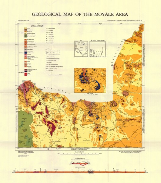
Geological mapping (1984) was carried out as part of the Samburu Marsabit Geological Mapping and Mineral Exploration Prokect, a joint Kenyan - British Overseas Development Administration Technical Co-operation Project, staffed by the Kenyan Mines and Geological Department and the Brtish Geological Survey (formerly the Institute of Geological Science) of Natural Environment Research Council. Series of 1: 250 000 scale geological maps captured in two phases. The maps cover central (phase 1) and northern Kenya (phase 2). The maps align with the 1: 500 000 scale map for the Northern Turkana area.
-
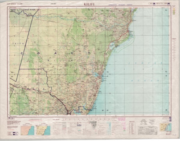
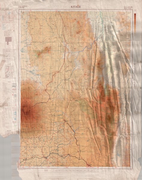
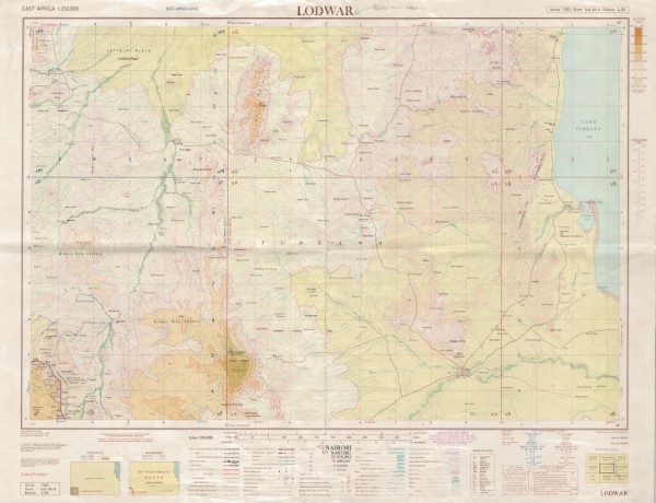
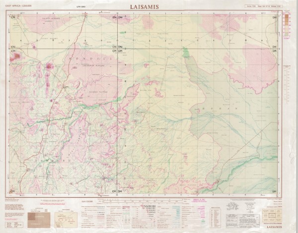
Y503 series of 1:: 250 000 scale topographic maps. Each map is a compilation from pre-existing published topographic maps mosty at 1: 50 000 scale (detailed on each map face). Series includes Kaabong, Aloi, jinja, in Uganda which was compiled and published by The Department of Lands and Surveys in Uganda. These maps use the New Arc (1960) datus Clarke 1880 (Modified) Spheroid UTM zone 36. Series also includes Musuma in Tanzania which was compiled by the Ministry of Lands, Forests and Wildlife, Tanganyika. Arusha was compiled by the Ministry of Lands, Settlement and Water Development Tanzania. Lushoto was compiled by the Ministry of Lands Surveys and Water Tanganyika. Series also include Kapenguria, Nyeri, Chuka, Chismaio, published by War office and Air Ministry using Transverse Mercator, Clarke 1880 (UTM Zones 36 and 37). Garsen was published by the Ministry of Defence (United Kingdom). CRS System: Various: Transverse Mercator, Clarke 1880; Arc 1960 (Clarke 1880); Arc 1960 (Clarke 1880) Zone 36S; Arc 1960 (Clarke 1880) Zone 36N; Arc 1960 (Clarke 1880) Zone 37S; Arc 1960 (Clarke 1880) Zone 37N, Arc 1960 (Clarke 1880) Zone 38N
-

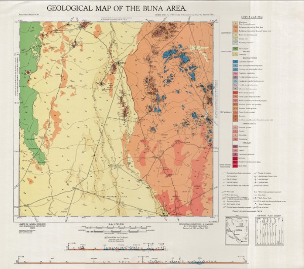
Geological mapping (1984) was carried out as part of the Samburu Marsabit Geological Mapping and Mineral Exploration Prokect, a joint Kenyan - British Overseas Development Administration Technical Co-operation Project, staffed by the Kenyan Mines and Geological Department and the Brtish Geological Survey (formerly the Institute of Geological Science) of Natural Environment Research Council. Series of 1: 250 000 scale geological maps captured in two phases. The maps cover central (phase 1) and northern Kenya (phase 2). The maps align with the 1: 500 000 scale map for the Northern Turkana area.
-
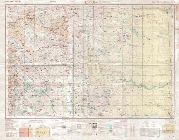
Y503 series of 1:: 250 000 scale topographic maps. Each map is a compilation from pre-existing published topographic maps mosty at 1: 50 000 scale (detailed on each map face). Series includes Kaabong, Aloi, jinja, in Uganda which was compiled and published by The Department of Lands and Surveys in Uganda. These maps use the New Arc (1960) datus Clarke 1880 (Modified) Spheroid UTM zone 36. Series also includes Musuma in Tanzania which was compiled by the Ministry of Lands, Forests and Wildlife, Tanganyika. Arusha was compiled by the Ministry of Lands, Settlement and Water Development Tanzania. Lushoto was compiled by the Ministry of Lands Surveys and Water Tanganyika. Series also include Kapenguria, Nyeri, Chuka, Chismaio, published by War office and Air Ministry using Transverse Mercator, Clarke 1880 (UTM Zones 36 and 37). Garsen was published by the Ministry of Defence (United Kingdom). CRS System: Various: Transverse Mercator, Clarke 1880; Arc 1960 (Clarke 1880); Arc 1960 (Clarke 1880) Zone 36S; Arc 1960 (Clarke 1880) Zone 36N; Arc 1960 (Clarke 1880) Zone 37S; Arc 1960 (Clarke 1880) Zone 37N, Arc 1960 (Clarke 1880) Zone 38N
-
Topographic map at 1: 250 000 scale which has been compiled from a series of exisiting maps. These include GSGS 4786 and GSGS 4787 (1: 50 000 scale), Mbale District, Survey of Kenya (1: 250 000 scale) Block 63 Kalossia and Block 76 Taiti (1: 125 000 scale) GSGS 3999 (1: 250 000 scale).
-
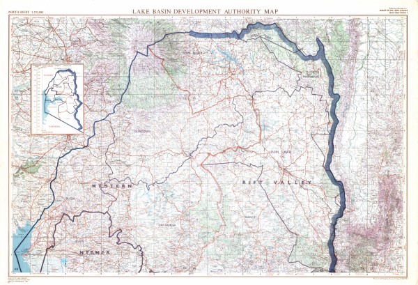
Lake Basin Developement Authority (North)
-
Y503 series of 1:: 250 000 scale topographic maps. Each map is a compilation from pre-existing published topographic maps mosty at 1: 50 000 scale (detailed on each map face). Series includes Kaabong, Aloi, jinja, in Uganda which was compiled and published by The Department of Lands and Surveys in Uganda. These maps use the New Arc (1960) datus Clarke 1880 (Modified) Spheroid UTM zone 36. Series also includes Musuma in Tanzania which was compiled by the Ministry of Lands, Forests and Wildlife, Tanganyika. Arusha was compiled by the Ministry of Lands, Settlement and Water Development Tanzania. Lushoto was compiled by the Ministry of Lands Surveys and Water Tanganyika. Series also include Kapenguria, Nyeri, Chuka, Chismaio, published by War office and Air Ministry using Transverse Mercator, Clarke 1880 (UTM Zones 36 and 37). Garsen was published by the Ministry of Defence (United Kingdom). CRS System: Various: Transverse Mercator, Clarke 1880; Arc 1960 (Clarke 1880); Arc 1960 (Clarke 1880) Zone 36S; Arc 1960 (Clarke 1880) Zone 36N; Arc 1960 (Clarke 1880) Zone 37S; Arc 1960 (Clarke 1880) Zone 37N, Arc 1960 (Clarke 1880) Zone 38N
-
Geological mapping (1984) was carried out as part of the Samburu Marsabit Geological Mapping and Mineral Exploration Prokect, a joint Kenyan - British Overseas Development Administration Technical Co-operation Project, staffed by the Kenyan Mines and Geological Department and the Brtish Geological Survey (formerly the Institute of Geological Science) of Natural Environment Research Council. Series of 1: 250 000 scale geological maps captured in two phases. The maps cover central (phase 1) and northern Kenya (phase 2). The maps align with the 1: 500 000 scale map for the Northern Turkana area.