 NGDC for Kenya
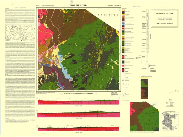
North Horr Geology
Geological mapping (1984) was carried out as part of the Samburu Marsabit Geological Mapping and Mineral Exploration Prokect, a joint Kenyan - British Overseas Development Administration Technical Co-operation Project, staffed by the Kenyan Mines and Geological Department and the Brtish Geological Survey (formerly the Institute of Geological Science) of Natural Environment Research Council.
Series of 1: 250 000 scale geological maps captured in two phases. The maps cover central (phase 1) and northern Kenya (phase 2). The maps align with the 1: 500 000 scale map for the Northern Turkana area.
Simple
- Date (Publication)
- 1988
- Edition
-
1
- Presentation form
- Digital map
- Collective title
-
Kenya 1:250 000 (Geology)
- Status
- Completed
- Maintenance and update frequency
- Not planned
- Keywords
-
-
Geology
-
- Use limitation
-
Internal Only
- Access constraints
- Other restrictions
- Other constraints
-
Internal Only
- Other constraints
- No specifed conditions apply
- Denominator
- 250000
- Metadata language
- English
- Topic category
-
- Geoscientific information
- Description
-
North Horr
))
- Supplemental Information
-
{"Translation Needs":"",
"Number of pages (Hardcopy)":"",
"Archive Location (Hardcopy)":"",
"Location in Archive (Hardcopy)":"",
"Risk and Impact":"",
"Vital asset to the organisation?":"",
"Current Asset Volume":"7.1",
"Digitalizing status":"Scanned & Georeferenced",
"Scanned Date":"",
"Name of Staff Scanning":"",
"Digital Asset location":" http://gdcs1.gdc.com/SpatialData/Raster/Geological/Scale_1_250000/Original_Arc1960_DD/North_Horr.jpg, http://gdcs1.gdc.com/SpatialData/Raster/Geological/Scale_1_250000/Tiff/North_Horr_200_dpi.tif",
"Retention period":"",
"Shared with":"",
"Comments":""}
- Distribution format
-
-
.jpg
()
-
.tiff
()
-
.jpg
()
- OnLine resource
-
North Horr Geology
Geological mapping (1984) was carried out as part of the Samburu Marsabit Geological Mapping and Mineral Exploration Prokect, a joint Kenyan - British Overseas Development Administration Technical Co-operation Project, staffed by the Kenyan Mines and Geological Department and the Brtish Geological Survey (formerly the Institute of Geological Science) of Natural Environment Research Council.
Series of 1: 250 000 scale geological maps captured in two phases. The maps cover central (phase 1) and northern Kenya (phase 2). The maps align with the 1: 500 000 scale map for the Northern Turkana area.
- Statement
-
The maps in this series are version 1, there is no evidence that the maps have been editied or updated and republished. Scanned copy of published paper map
- File identifier
- dd3a6d94-b3e9-495f-a5af-217bf1e23788 XML
- Metadata language
- English
- Parent identifier
-
Kenya 1:250 000 (Geology)
Kenya 1:250 000 (Geology)
- Hierarchy level
- Dataset
- Date stamp
- 2019-10-22
- Metadata standard name
-
National Geodata Centre for Kenya Schema
- Metadata standard version
-
1.0
Overviews
Spatial extent
Provided by
