 NGDC for Kenya
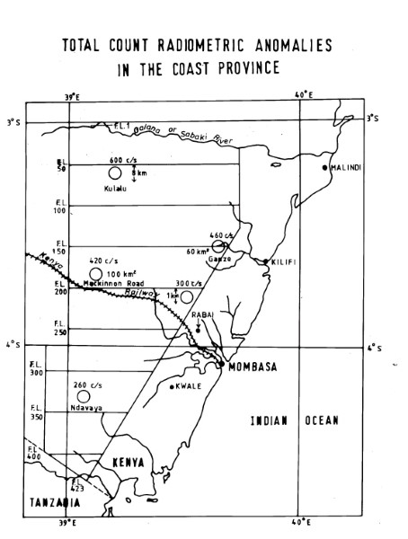
Total Count Radiometric Anomolies Coast Province
Single map showing flight lines for coastal survey. No information is given as to the source or reference to any other information which may have been collected. May be part of a report or wider study.
Simple
- Date (Publication)
- Presentation form
- Digital map
- Status
- Completed
- Maintenance and update frequency
- Not planned
- Keywords
-
-
Geophysics
-
Radiometrics
-
Total Count
-
- Use limitation
-
Internal Only
- Access constraints
- Other restrictions
- Other constraints
-
Internal Only
- Other constraints
- No specifed conditions apply
- Metadata language
- English
- Topic category
-
- Geoscientific information
- Description
-
Kenya
- Supplemental Information
-
{"Translation Needs":"",
"Number of pages (Hardcopy)":"",
"Archive Location (Hardcopy)":"",
"Location in Archive (Hardcopy)":"",
"Risk and Impact":"",
"Vital asset to the organisation?":"",
"Current Asset Volume":"0.65",
"Digitalizing status":"Scanned",
"Scanned Date":"",
"Name of Staff Scanning":"",
"Digital Asset location":" http://gdcs1.gdc.com/SpatialData/Raster/Geological/Radiometric/Total_Count_Radiometric_Anomolies_Coast_Province.jpg",
"Retention period":"",
"Shared with":"",
"Comments":""}
- Distribution format
-
-
.jpg
()
-
.jpg
()
- OnLine resource
-
Total Count Radiometric Anomolies Coast Province
Single map showing flight lines for coastal survey. No information is given as to the source or reference to any other information which may have been collected. May be part of a report or wider study.
- Statement
-
No details of the source or history of the survey undertaken are currently available. Scanned copy of published map.
- File identifier
- e39ea735-8cca-4625-82d4-dfe700e77faf XML
- Metadata language
- English
- Hierarchy level
- Dataset
- Date stamp
- 2019-10-22
- Metadata standard name
-
National Geodata Centre for Kenya Schema
- Metadata standard version
-
1.0
Overviews
Spatial extent
Provided by
